Editor: 邵丹蕾 Author: School of Humanities Time: 2017-10-18 Number of visits :170

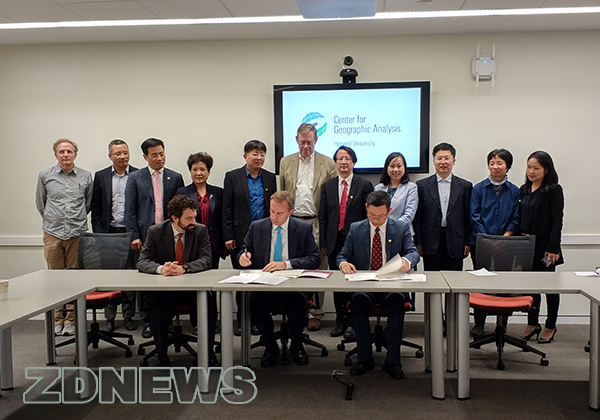
From October 12 to 13, 2017, Wu Zhaohui, the president of Zhejiang University, led a delegation to visit Harvard University, aiming to deepen the strategic cooperation between the two universities. In the afternoon of the 13th, leaders and experts of two universities attended a signing ceremony of a Memorandum of Understanding on cooperation to build an academic mapping platform at the Center for Geographic Analysis.
The leaders and experts of Zhejiang University at the signing ceremony included: Wu Zhaohui, the President of Zhejiang University; Xu Xiaozhou, Dean of the Academy of Humanities and social Sciences; Li Min, Director of the office of International Relations; Xu Yongming, Professor of the school of Humanities; Zhang Feng, Associate Professor of School of Earth Sciences; and so on. The leaders and experts of Harvard University are as follows: Peter K.Bol, Vice Provost of Harvard University and Professor in the Department of East Asian Languages and Civilizations; Mark Elliott, Vice Provost of Harvard University and Professor in the Department of East Asian Languages and Civilizations and the Department of History; Jason Ur, Director of the Center for Geographic Analysis and Professor of Anthropology in the Department of Anthropology; Wendy Guan, Executive Director of the Center for Geographic Analysis; Ben Lewis, Geospatial Technology Manager; Elizabeth Hess, Executive Director of Harvard Institute for QuantitativeSocial Science,and so on.
At the start of the meeting, Professor Peter Bol introduced the background of the foundation of the Center for Geographic Analysis, emphasizing the importance of geographic information system and GIS technology, and the urgency of promoting the development of related technologies. The establishment of the Center provided a common platform for the integration of spatial data from diverse sources and knowledge from multiple disciplines. Professor Bol also described the application of GIS in the field of ancient Chinese literature and history, and pointed out that spatial analysis and visualization play an important role in humanities and social science research. Finally, Professor Bol expressed his hope of cooperating with Zhejiang University and promoting the use of GIS technology in Chinese academic research. Afterwards, Prof. Mark Elliottexpressed his welcome to the delegation of Zhejiang University. Hebelieved that this cooperative project is a majorbreakthrough. Itwould promote the creation of knowledgeto help people study better and live better,which could help the two institutions achieve their common goal of seeking truth, as the mottosof both universities indicated. He thanked people ofboth sides for their efforts in this cooperation and senthis sincere congratulations.
Wu Zhaohui, the president of Zhejiang University highly affirmed the importance of GIS in the study of humanities and social sciences, and believed that the combination of technical foundation of Harvard University and China's data resources will be mutually beneficial and bring meaningful cooperation. He also pointed out that society in the future would see the integration of the physical world and the virtual world, which would form new scientific problems, and GIS is an important intersection of these two worlds. Incorporating the spatial dimension, visualization and analysis of China's long history by the means of GIS will be very meaningful. He hoped that this signingwas a new starting point for cooperation and the two universities would have more in-depth cooperation in the future.
After that, Prof.Xu Xiaozhou, Prof. Xu Yongming, Prof. Mark Elliott and Prof.Jason Ur, representing leadership of the two universities and the project teams respectively, signed the memorandum of understanding.
Geographical information is closely related to human activities. Examples includethe geographical distribution of the historical figures, the traces and the social relations for individuals,the migration of a group, as well as the inhabitants, distribution and change of a region and trajectory for non-living things; as for a place, it also contains the people, affairs, things and other geographical information in previous times. The twenty-first century is the era of digital information, and countries are pushing forward the process of the digitization of their own documentation andthe establishment of distinct types of databases. In the process of digitalization, the construction of GIS-based human geographical information database is showing an ascendant trend. The World Map website, established by Harvard University, is a geographical information database platform for visual query.Scholars around the world can publish relevant research results on this platform. For instance, the Chinese part includes geographic information and visual maps such as demography, religion, transportation, urban studies, ethnic minorities and languages, energy, environment, education, climate, public health, economy, history and many other fields.
Because China has no comprehensive academic mapping platform, Zhejiang University and Harvard University will jointly build anacademic map-publishing platform suitable for operation in China. After completion, the platform will provide most users with the release of geographic information research results, visual analysis, and multi-functional query services. Furthermore, data produced by the platform will greatly enhance future scientific research, government decision-making, and social services.
Reprinted from School of Humanities, Zhejiang University
