

Editor: 邵丹蕾 Author: CHEN Yangkang Time: 2019-10-09 Number of visits :216
USArray, a pioneering project for the dense acquisition of earthquake data, provides a semi- uniform sampling of the seismic wavefield beneath its footprint and greatly advances the understanding of the structure and dynamics of Earth. Despite continuing efforts in improving the acquisition design, network irregularity still causes spatial sampling alias and incomplete, noisy data, which imposes major challenges in array-based data analysis and seismic imaging.
In the study of Chen et al. (2019), they develop an effective framework to reconstruct the three-dimensional (3D) data of an earthquake recorded by USArray, i.e., obtaining free USArray recordings as well as enhancing the existing data. They propose a localized rank-reduction method to simultaneously reconstruct the missing traces and improve the weak-amplitude phase arrivals. Compared with the regular global rank-reduction method, their localized approach is superior at preserving the small-scale features in the array data, which is critical for high-resolution imaging of subsurface structures. Chen et al. (2019) demonstrate its signal-improvement capability via a synthetic dataset and then apply the proposed method to January 18, 2009, Kermadec Islands Mw 6.4 earthquake recorded by USArray, where a significant portion of the recordings is missing due to deployment limitations. The reconstructed P wavefield enhances the spatial coherency and accuracy of tomographic travel time measurements, which demonstrates great potential to benefit seismic investigations based on array techniques.
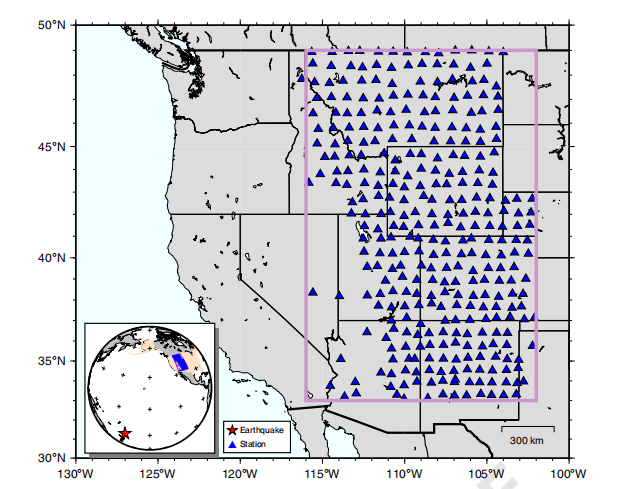
Fig. 1 The distribution of USArray stations in this study. The lateral dimension of the reconstructed data volume is highlighted by the rectangle. A large portion of the data is missing due to relatively spare station coverage in the southwest. The inset shows the location of the earthquake (red star) relative to the recording array (blue triangles)
This study is led by Yangkang Chen, who is a Hundred-Talent-Plan research professor at the School of Earth Sciences, Zhejiang University.
Reference: Chen, Y., M. Bai, and Y.F. Chen, 2019, Obtaining free USArray data by multi-dimensional seismic reconstruction, Nature Communications, 10:4434, doi: 10.1038/s41467-019-12405-0.
Link to the paper:https://www.nature.com/articles/s41467-019-12405-0