Editor: 邵丹蕾 Author: HE Yuxin Time: 2022-02-21 Number of visits :191
Based on biomarkers and bulk organic carbon isotope, we reconstructed a 5-million-year history of terrestrial material input to the northwest shelf of Australia. Vegetational organic input continuously decreased through the Pliocene-Pleistocene period due to decreased vegetation coverage and discharge under general aridification process. Triggered by lowered sea level and drier climates, soil input increased after ~2.5–2.2 million years ago (Ma). Bulk terrestrial organic input demonstrates stronger variability after ~1.7 Ma, as influenced by large-amplitude hydrological swings on the Australian continent. Source of soils shifted between ~1.5–1.2 Ma, along with presence of active dune fields. All lines of evidence together indicate a general wet climate in northwestern Australia during the early Pliocene, a continuously drying trend to the mid-Pleistocene, and a drier phase with less vegetation coverage and expanded desert during the late Pleistocene, which is modulated by ongoing Indonesian Throughflow constriction and global atmospheric circulations.
Article information: He, Y., & Wang, H. (2021). Terrestrial material input to the northwest shelf of Australia through the Pliocene-Pleistocene period and its implications on continental climates. Geophysical Research Letters, 48, e2021GL092745.
https://doi.org/10.1029/2021GL092745

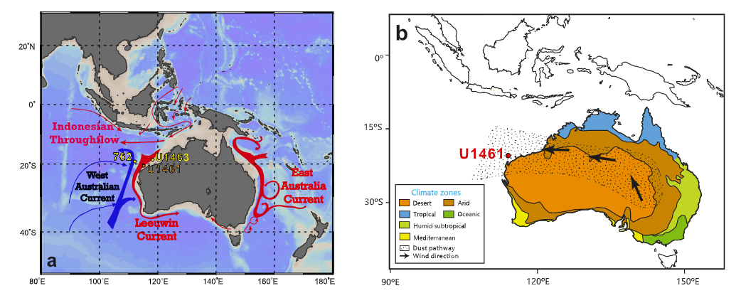
Figure 1. (a) Modern oceanography (created by the software of Ocean Data View), ocean circulations in the Indo-Pacific and Australian regions (adapted from Gallagher et al., 2009), and the positions of International Ocean Discovery Program (IODP) Sites U1461, U1463, and ODP 762. Warm and cold surface currents were shown in red and blue arrows. (b) Modern Australian climatic zones and dust pathway (adapted from Christensen et al., 2017).

Figure 2. Compilation of terrestrial material input and climates of northwestern Australia over the last 5 million years. (a) Vegetational organic carbon input inferred by C31Alk/C28–30Str values at Site U1461 (black, three-point smoothing). Mean annual precipitations in southern Australia based on Monte Carlo simulations on the continental vegetation change (red with 1σ error shadows, Sniderman et al., 2016). (b) δ13Corg values at Site U1461 (brown, three-point smoothing). (c) Soil input inferred by uranium concentrations from Site U1463 (orange, Christensen et al., 2017) and BIT values from Site U1461 (dark blue, three-point smoothing) and Site U1463 (light blue, Smith et al., 2020). (d) Source of soils inferred by MBT and CBT values (three-point smoothed) from Site U1461. (e) River runoff and terrigenous input based on percentage of potassium (%K) from Site U1463 (blue, Auer et al., 2020; Christensen et al., 2017) and log(Fe/Ca) record from Site 762 (green, Auer et al., 2020; Stuut et al., 2019). (f) Global sea level record (blue, De Boer et al., 2010) derived from global benthic δ18O records (Lisiecki & Raymo, 2005), and some local and global events including the onset of the Northern Hemispheric Glaciation (NHG), the mid-Pleistocene transition (MPT), and the MIS 50–60, 100, G2, and M2 events (green). Gray shadings indicate weak ITF events (same with Figure 2). A summary of terrestrial material input and climatic variations in northwestern Australia is shown at the bottom.
