Editor: 谢佳 Author: Time: 2023-10-24 Number of visits :181
The India-Eurasia collision caused the uplift of the Tibetan Plateau and extensive intracontinental deformation over a broad area of Asia during the Cenozoic. Located more than 1,000–2,000 km to the north of this collision zone, the 2,500-km-long Tian Shan, with numerous peaks over 7,000 m, is a seismically active orogenic belt and has experienced Cenozoic tectonic reactivation and rapid uplift since the Miocene. The uplift of the Tian Shan has affected the geosystem in at least two aspects. On one hand, the significant topography of the Tian Shan has played a key role in the climate evolution of Central Asia since the Late Miocene; on the other hand, the deformation propagated and disrupted adjacent foreland basins, resulting in the development of a series of fold-and-thrust belts (FTBs) that encode key deformational and erosional records of the Tian Shan. GPS velocity field indicates that the Western Tian Shan accommodates nearly 40% of the present-day total convergence between Indian and Eurasia plates. Moreover, atthe northern and southern edges of the Tian Shan, 80%–90% of the current N-S shortening is absorbed by the foreland FTBs. However, due to the spatial diversity of foreland basins, how this massive shortening accumulated and propagated within the orogen-basin system remains unclear, and is critical for the understanding of the outward growth of the Tian Shan and related continental tectonics in central Asia.

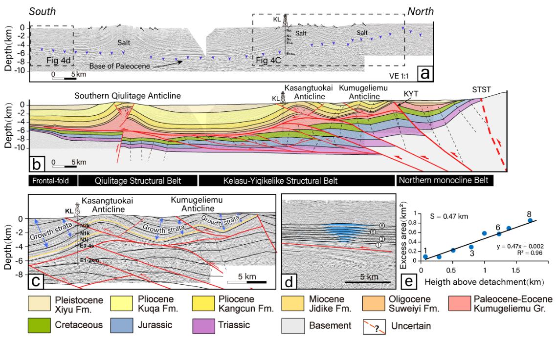
Figure 1. Interpreted seismic reflection profile A-A' and shortening estimate for the detachment fold within the Front fold belt. (a) Uninterpreted depth seismic profile A-A'. (b) Geological interpretation of the seismic profile A-A'. (c) Enlarged detail from part of seismic reflection profile A-A'. (d) Interpretation of the buried detachment fold. (e) The resultant area-depth (height) graph of the blind detachment fold.
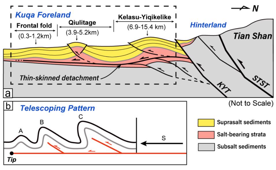
To address these issues, we interpreted three high-resolution seismic reflection profiles to estimate the magnitude and distribution of Cenozoic shortening across the Eastern Kuqa FTB, South Tian Shan foreland (Figure 1). Combined with well-dated syn-tectonic stratigraphy, we further evaluate the timing, rate, and migration of the deformation front of the Kuqa FTB. Our results suggest that the Kuqa FTB's total crustal shortening increases westward. The distribution of crustal shortening across secondary structural belts shows a gradual, basinward decrease, which can be explained by the telescoped mechanism (Figure 2). Propagation rates of the Kuqa FTB's deformation front indicate an episodic propagation of the foreland thrust wedge, with an acceleration after ∼12 Ma. Similar episodic propagation pattern has also been observed in other foreland FTBs around the Tian Shan, but they show significant spatiotemporal variations in the propagation stages and related rates (Figure 3).

Figure 2. Schematic diagram showing displacement distribution (with a telescoping pattern) and distribution of shortening in the Eastern Kuqa fold-and-thrust belt (FTB).

Figure 3. Late Cenozoic shortening, basinward deformation propagation, and sediment progradation rates in the Tian Shan foreland basins.
Feng Li, the first author of this paper, is a doctoral candidate at the School of Earth Sciences, Zhejiang University. Professor Hanlin Chen and Professor Xuhua Shi of Zhejiang University are the corresponding authors. This research is supported by the National Key Research and Development Program of China (Grants 2019YFC0605501 and2022YFC3003704), National Natural Science Foundation of China (Grants U22B6002, 41720104003, 51988101, 41941016, and 41972227).
Article information: Feng Li., Xiaogan Cheng., Hanlin Chen*., Xuhua Shi*., Yong Li., Julien Charreau., and Ray Weldon., 2023, Cenozoic Shortening and Propagation in the Eastern Kuqa Fold-And-Thrust Belt, South Tian Shan, NW China [J] Tectonics, doi:10.1029/2022TC007447.
